Netherlands: along the North Sea Coast
Even though we have only ridden a small portion the Netherlands, primarily between Amsterdam and Rotterdam and along the Maas river, the Internet sites and information listed here should be helpful to anyone bicycling in the Netherlands. One could probably spend a lifetime bicycling in this country and never have ridden all of the routes. The Netherlands is a bicycling wonderland, 36% of people in the country use a bicycle as their primary form of transportation. Excellent bicycling infrastructure such as cycle paths, cycle tracks, protected intersections and abundant bicycle parking make travel by bicycle easier than by automobile.
Where ever you are going in the Netherlands, you can get there by bicycle. For maps try opencycle map or maps.me. All of the cycle routes shown on the maps seem to be there on the ground even though they may be hard to find in places. Almost every street in the Netherlands has a bicycle path, lane or shoulder. There isn't much need to follow the formal feits routes since every street is bike-able.
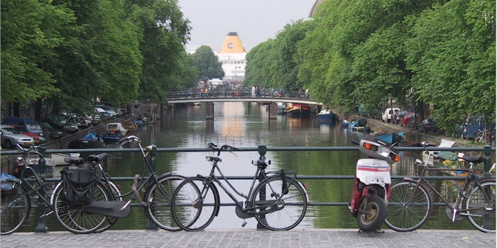
One of the many canals in Amsterdam. Bike are everywhere even in the canals.
The Netherlands is perhaps the best country in the world to explore by fiets (bicycle). The long distance cycling routes, landelijke fietsroutes (LF) is a network of routes that are designed to get you from one place to another. The LF routes total about 4,500 kilometers, all are well marked with distinctive green and white signs. The routes mostly use bicycle lanes on rural roads and designated bicycle paths.
Guides, Maps and Other Information
Holland Cycling Routes. This is the place to start for finding long distance routes in the Netherlands. "hollandcyclingroutes.com is an initiative of Landelijk Fietsplatform the official Dutch organization for recreational cycling." The long distance LF (Landelijke Fietsroutes) routes are listed here.
The Netherlands LF routes are being revised. For updates to the changes click here. In Dutch but Google Translate does a good job of translating.
Before you traveling an (LF-) route, always check whether there are current issues that can affect your trip. For example, a temporary road diversion, a ferry that is out of service or a review of a node network. For a list of LF issues click here.
Holland Cycling. An excellent privately operated site with a list of LF routes and much other information. A great planning resource.
Holland Cycling Federation Another source of online maps for routes in the Netherlands. Has a mobile option.
![]() EuroVelo 12 In the Netherlands the North Sea Cycle Route follows the Noordzee route from the border near Sluis to Callantsoog (LF1) and in the north to the Waddenzee route (LF10). In the south the LF1 runs across the islands of the south-west part of the Netherlands.
EuroVelo 12 In the Netherlands the North Sea Cycle Route follows the Noordzee route from the border near Sluis to Callantsoog (LF1) and in the north to the Waddenzee route (LF10). In the south the LF1 runs across the islands of the south-west part of the Netherlands.
Maas Cycleway. Starting near Rotterdam and traveling 1100 km into northern France, the Meuse cycleways is one of the easiest routes in Europe to navigate and ride. A huge number of cultural and historic attractions are present on this cycleway.
![]() Friends of Bicycles Primarily places to stay in Netherlands, "Vrienden op de Fiets enables bikers and hikers to stay overnight with one of the 6,000 hospitable people along routes throughout the Netherlands and abroad."
Friends of Bicycles Primarily places to stay in Netherlands, "Vrienden op de Fiets enables bikers and hikers to stay overnight with one of the 6,000 hospitable people along routes throughout the Netherlands and abroad."
![]() Region of Brabant Lists many popular bicycle routes."
Region of Brabant Lists many popular bicycle routes."
See the Maps and Guides page for more mapping information.
Map information
![]() Holland Cycling Route Planner. lists all of the Netherlands LF routes in red. GPX tracks are available on this page.
Holland Cycling Route Planner. lists all of the Netherlands LF routes in red. GPX tracks are available on this page.
There are many offline cycling apps with maps available for iphone and android. A couple of the better offline apps are listed here.
![]() Can be used to follow this route (and other routes). Click here for a KML file that can be loaded into the app: Netherlands LF Routes. Place the file in the maps.me bookmarks folder (MapsWithMe/bookmarks on your phone or tablet) or alternately, email/text it to your device and open the file with maps.me. Total Commander works great for managing and opening files.
Can be used to follow this route (and other routes). Click here for a KML file that can be loaded into the app: Netherlands LF Routes. Place the file in the maps.me bookmarks folder (MapsWithMe/bookmarks on your phone or tablet) or alternately, email/text it to your device and open the file with maps.me. Total Commander works great for managing and opening files.
![]() Guru Maps has the ability to show map types other than OpenStreetMap, in particular it will display OpenCycleMap. KML files can be imported by "opening" the file with Guru. To import the KML file place the file in a folder or email/text it to your device, press and hold and open with the app. The route will appear in "collections." A user manual is available.
Guru Maps has the ability to show map types other than OpenStreetMap, in particular it will display OpenCycleMap. KML files can be imported by "opening" the file with Guru. To import the KML file place the file in a folder or email/text it to your device, press and hold and open with the app. The route will appear in "collections." A user manual is available.
What it is Like
- Travel Tips
Many hotels near Schiphol airport have free shuttles to and from the airport. You can start you ride from the almost any hotel in the area. Just use the convenient bike paths.
- Ride Quality
All of the fiets routes we encountered were paved and in good condition. All roads have some kind of passage for bicycles such as separate path along the busy roads or space for bicycles on the quieter roads.
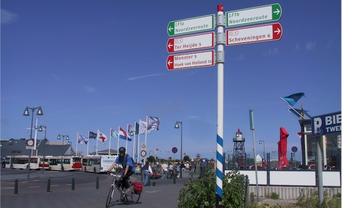
Signs for the LF1 Noordzeeroute along the coast.
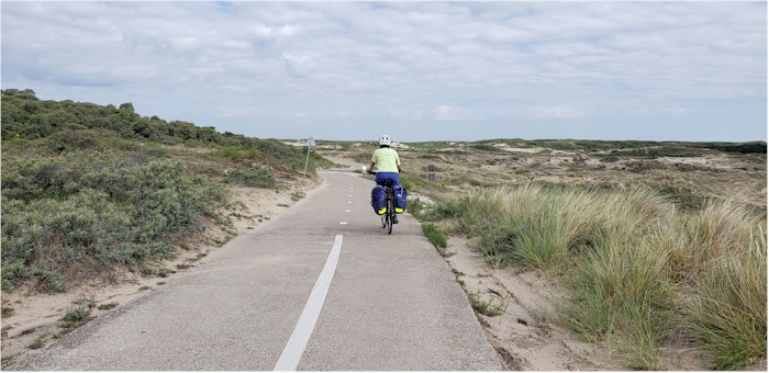
North Sea Route bicycle path. This is a high quality path that travels the length of the country. Beware of winds along the coast.
The North Sea Path follow the coast to the north and south borders, traveling through many seaside resort towns. Winds are generally from the South and West and can be formidable. Services and plentiful along the way, you are never far from coffee and croissants or herring.
- Elevation Change
The Netherlands are flat, perhaps with the least elevation change of any country in Europe
- Best Season
Spring and fall. Summers in Europe are increasingly hot and there are few accommodations with air conditioning.
Riding along the dikes in the low country. Dike paths offer some of the best riding since they are vehicle free and will take you to many interesting places.
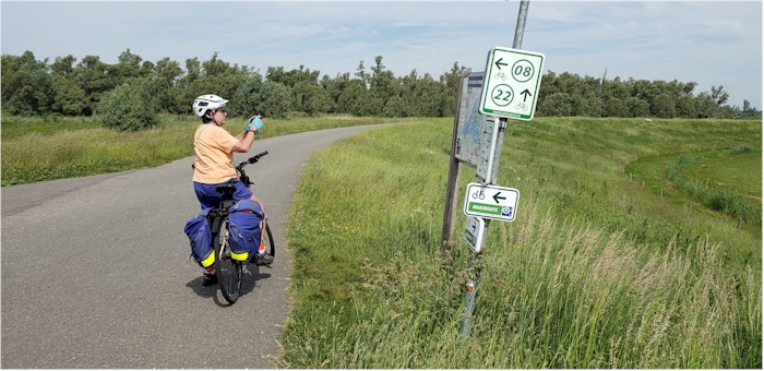
Most the cycle routes in the low lying areas of the Netherlands follow dikes. These routes are well signed with maps to take the rider from point to point. Just follow the numbers on the maps.
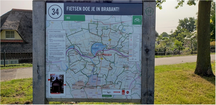
Bicycle route map. These signs seem to be present at most major intersections and are very helpful for determining the next section of your ride.